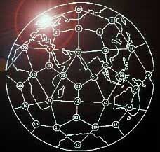
Unique Geologic Features at Every World Grid Point

The EarthStar Globe copyright 1984 Bethe Hagens and Bil Becker.
|
No. |
Lat. |
|
Long. |
|
Description |
|
1 |
31.72 |
N |
31.2 |
E |
On the Egyptian
continental shelf, in the |
|
2 |
52.62 |
N |
31.2 |
E |
On the |
|
3 |
58.28 |
N |
67.2 |
E |
In the marshy lowlands just west of Tobolsk |
|
4 |
52.62 |
N |
103.2 |
E |
In the lowlands north of the southern tip of lake Baykal, at the edge of highlands |
|
5 |
58.28 |
N |
139.2 |
E |
In the highlands along
the coast of the |
|
6 |
52.62 |
N |
175.2 |
E |
Slightly east of |
|
7 |
58.28 |
N |
148.8 |
W |
Edge of continental
shelf in the |
|
8 |
52.62 |
N |
112.8 |
W |
|
|
9 |
58.28 |
N |
76.8 |
W |
Just east of Port
Harrison on |
|
10 |
52.62 |
N |
40.8 |
W |
Gibbs Fracture Zone |
|
11 |
58.28 |
N |
4.8 |
W |
Loch More on the west
coast of |
|
12 |
26.57 |
N |
67.2 |
E |
On the edge of the |
|
13 |
31.72 |
N |
103.2 |
E |
At the east edge of the |
|
14 |
26.57 |
N |
139.2 |
E |
At the intersection of Kydshu Palau Ridge, the West Mariana Ridge, and the Iwo Jima Ridge |
|
15 |
31.72 |
N |
175.2 |
E |
At the intersection of Hess Plateau, the Hawaiian Ridge, and the Emperor Seamounts |
|
16 |
26.57 |
N |
148.8 |
W |
North East of Hawaii, midway between the Murau Fracture Zone and the Molokai Fracture Zone |
|
17 |
31.72 |
N |
112.8 |
W |
Cerro Cubabi, a highpoint just south of the US/Mexico border near Sonoita and lava fields |
|
18 |
26.57 |
N |
76.8 |
W |
Edge of continental
shelf near |
|
19 |
31.72 |
N |
40.8 |
W |
Atlantis Fracture Zone |
|
20 |
26.57 |
N |
4.8 |
W |
In El Eglab, a highland peninsula at the edge of the |
|
21 |
10.81 |
N |
31.2 |
E |
Sudan Highlands, at the
edge of |
|
22 |
0 |
|
49.2 |
E |
Somali Abyssal Plain |
|
23 |
10.81 |
S |
67.2 |
E |
Vema Trench (in the |
|
24 |
0 |
|
85.2 |
E |
|
|
25 |
10.81 |
N |
103.2 |
E |
Kompong Som, a
natural bay on the southern coast of |
|
26 |
0 |
|
121.2 |
E |
At the midpoint of Teluk, Tomini, a bay in the
northern area of |
|
27 |
10.81 |
S |
139.2 |
E |
Midpoint of the mouth of
the |
|
28 |
0 |
|
157.2 |
E |
Center of |
|
29 |
10.81 |
N |
175.2 |
E |
Midpoint of abyssal
plain between |
|
30 |
0 |
|
166.8 |
W |
Nova |
|
31 |
10.81 |
S |
148.8 |
W |
|
|
32 |
0 |
|
130.8 |
W |
Galapagos Fracture Zone |
|
33 |
10.81 |
N |
112.8 |
W |
East end of the Clipperton Fracture Zone |
|
34 |
0 |
|
94.8 |
W |
Junction of the Cocos Ridge and the Carnegie Ridge, just west of the |
|
35 |
10.81 |
S |
76.8 |
W |
|
|
36 |
0 |
|
58.8 |
W |
State of |
|
37 |
10.81 |
N |
40.8 |
W |
Vema Fracture Zone |
|
38 |
0 |
|
22.8 |
W |
Romanche Fracture Zone |
|
39 |
10.81 |
S |
4.8 |
W |
Edge of Mid-Atlantic
Ridge in |
|
40 |
0 |
|
13.2 |
E |
|
|
41 |
26.57 |
S |
31.2 |
E |
L'uyengo on the |
|
42 |
31.72 |
S |
67.2 |
E |
Intersection of the Mid-Indian Ridge with the Southwest Indian Ridge |
|
43 |
26.57 |
S |
103.2 |
E |
Tip of the Wallabi Plateau |
|
44 |
31.72 |
S |
139.2 |
E |
In a lowland area just
east of |
|
45 |
26.57 |
S |
175.2 |
E |
At the edge of the
Hebrides Trench, just southwestof the |
|
46 |
31.72 |
S |
148.8 |
W |
Undifferentiated |
|
47 |
26.57 |
S |
112.8 |
W |
Easter Island Fracture Zone |
|
48 |
31.72 |
S |
76.8 |
W |
Nazca Plate |
|
49 |
26.57 |
S |
40.8 |
W |
In deep ocean, at edge
of continental shelf, southeast of |
|
50 |
31.72 |
S |
4.8 |
W |
Walvis Ridge |
|
51 |
58.28 |
S |
31.2 |
E |
Enderby Abyssal Plain |
|
52 |
52.62 |
S |
67.2 |
E |
Kerguelen Plateau |
|
53 |
58.28 |
S |
103.2 |
E |
Ocean floor, midway between Kerguelen Abyssal Plain and Wilkes Abyssal Plain |
|
54 |
52.62 |
S |
139.2 |
E |
Kangaroo Fracture Zone |
|
55 |
58.28 |
S |
175.2 |
E |
Edge of Scott Fracture Zone |
|
56 |
52.62 |
S |
148.8 |
W |
Udintsev Fracture Zone |
|
57 |
58.28 |
S |
112.8 |
W |
Eltanin Fracture Zone |
|
58 |
52.62 |
S |
76.8 |
W |
South American tip, at the edge of the Haeckel Deep |
|
59 |
58.28 |
S |
40.8 |
W |
South Sandwich Fracture Zone |
|
60 |
52.62 |
S |
4.8 |
W |
Boivet Fracture Zone |
|
61 |
|
|
North Pole |
||
|
62 |
|
|
South Pole Notes:1. Chris Bird r = radiation d = diamond center
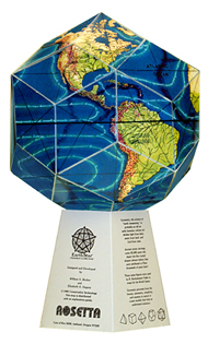
The flat EarthStar map (made up of thirty diamonds) folds up into a globe. Globe on its stand is 10.75 inches high. Available exclusively here at VortexMaps.com $25 includes free shipping worldwide. Daniel Evan Shaw, website copyright © 2024 |
