More on the figures:
The figures are all very large geometric forms that have the points, and often have the intersections, marked. They are all related in a most ingenious manner. The main figure is a line that passes through the center of the province. My studies show that it passes across the Gulf of Maine into the United States. It passes through the U.S. crossing many interesting points including those which intersect the figures found by the people on the
Arkhom project, and then across the Gulf Of Mexico to the north of Mexico City near Teotihuacan, Tula and other interesting places. On its way there, the line passes directly through Plymouth Rock, then down to Washington D.C. On its way, the line passes through Long Island, New York somewhere between Shoreham and Montauk, each of which has an interesting history. I have not yet traced the line back toward Europe, but a quick peek shows an obvious trend toward Northern Ireland, then Scotland. I am very interested in that direction as well. It falls in nicely with the connection with the Scotland connection with the Knight's Templar through the St. Claire {Sinclair} family at Roslin.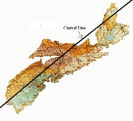
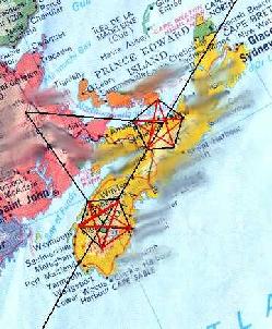
The central line passes through the Province and is marked at significant points with markers and monuments, just as the more complex figures are. Several of the figures are centered on this line. It is along this line that we can introduce the mystery of the place naming convention here in NS and abroad. There are four places along this line that are all involved with the larger geometry, that are called "Pleasant Valley". Each of these places has some mysterious aspects, not the least of which is their association with the figures. As well, there are several other "Pleasant Valleys" in NS, all associated with the figures. The are also several "Point Pleasants and a few "Pleasant Points". All are involved. There is, in Nova Scotia, a place called "
Oak Island" which is world famous as a mystery/treasure site. What most people do not know, is that there are five "Oak Islands" in Nova Scotia. All of them are involved, in a beautifully ingenious manner, with the figures. Also, the site in New Ross that has made some people speculate, is on that line and is a point in one of the pentagrams.On the central line, there is a large triangle that is bounded by a Pleasant Valley, a place called McGowan Lake where the Mi'kmaq Indians made many thousands of hieroglyphs, some in a script that is surprisingly similar to ancient Egyptian glyphs, and a place in New Brunswick called Red Bank.
Red Bank is the site of a series of Mi'kmaq mounds that are making historians back the time scale of the Mi'kmaq's presence thousands of years earlier than expected, and which contain items that connect those very early North Americans with a trade area much larger than originally thought.
This triangle is the base for two pentagrams that involve, among other things, several Oak Islands, a few Pleasant Valleys, a couple of "Crosses" and at least three places that I, and others, feel are sites that indicate intelligent, globally aware construction and inhabitation by pre-Columbian North Americans.