Bill Becker (Professor of Industrial Design at the University of Illinois, Chicago) and Bethe Hagens (Professor of Anthropology at Governors State University) were a husband-wife team. In 1981, they started a product and graphics design partnership, Conservative Technology.
“The experience of life in a finite, limited body is specifically for the purpose of discovering and manifesting supernatural existence within the finite.” Attributed to Pythagoras
Introduction
We’ve entitled our current exercise in planetary grid research “A New Synthesis” - and indeed we hope it is. All that may be new about our work is that we have simply found a unique blend of the previously “unblended” ideas of others. Those others are true visionaries in the areas of unexplained earth phenomena, human history, discovery, and the art-science of geometry (earth measure). Over the last year and six months, we’ve received literally hundreds of letters from researchers all over the globe - who are seeking a comprehensive explanation for a continuum of phenomena and events which traditional science emotionally rejects as “impossible,” “hallucinatory,” and/or “unquanitifiable.”
Yet the events continue to be catalogued, with many reports suppressed or labelled “fraud” by orthodox scientists. Worldwide networks of questioning theorists persist and grow with each report. We will try to mention as many of our correspondents as we can within the text of this article. Several contributors, listed at the end, have truly transformed our view of this work.
In 1200 A.D., a new energy began to move within the cultures of the West. After centuries of obedient reflection within the established order of Roman Christianity, the spirit of individualism and exploration began to emerge. The 14th century great plagues of Europe, in which one fourth of the Continental population had died - with three out of four persons afflicted, had awakened in the West the archetypal imperative to “control Nature or die!” By the 15th century, Leonardo da Vinci and the multi-disciplined geniuses of the Renaissance had rediscovered the lost scientific principles of pre-Christian Greece and Rome, and had invented the “view point” of the individual within their perspective drawing and painting systems. Paintings and public murals now began to put the individual at the center of a “world view” which, for the first time in centuries, conveyed the notion that through individual effort and analysis, the person - the viewer - could come to order and “control” the often hostile natural environment.
This “individual point of view” (perspective view point on “horizon”) required “detached awareness” (standing distant from that which is viewed) and a consummate dedication to visual detail and analysis in order to “render an in-depth perspective.” The writing and journalism of today still ring with the Renaissance archetypes.
Now it is 500 years later, and Leonardo’s manifest symbol of individual view point and detachment has brought us to viewing video discs of the earth as seen from the moon. It has also brought us to the uneasy conclusion that our pre-Renaissance imperative to control Nature (literally “that which is born”) or die has ushered us into a technological malaise where most of our man-made “natural” control systems are in crisis - especially those systems which exploit, pollute, or dramatically disturb the biospheric processes of the earth.
Just as the perspective pictorial systems of the Renaissance artists “brought into focus” the unspoken cultural archetypes of their time, we feel that the current network of planetary grid researchers (of whom we are a part) may be on a similar path toward developing a unifying symbol of a new earth: a paradigm as transcendent over our passing “Iron Age” as the Renaissance was over the Dark Ages.
What may make the proposition even more fascinating is the parallel analogy that - just as the driving force behind the creative energies of the Renaissance was the rediscovery of Greco-Roman science/philosophy; so with our planetary grid theorists, the driving force behind most research efforts is the continuing flow of evidence, both physical and metaphysical, that the existence of Pre-Egyptian civilizations - some with highly advanced technologies - is now no longer speculative, but a necessary assumption for developing any comprehensive archaeological treatise.1
We believe that the planetary grid is an ancient model that brings control through comprehensive understanding and not through detached myopic analysis/manipulation. The contemporary video artist/philosopher Dan Winter expresses the idea beautifully.
“Our destiny is to encounter our embracing collective mind with increasing intimacy and resonance. We awaken to a love life, in which personal love expands to planetary love - through this touching new body of mindfulness. A new body of mind crystallizes among us.”2
Planetary Grid Researchers: Prehistoric to Present
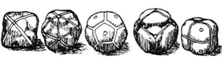
The oldest evidence of possible planetary grid research rests within the Ashmolean Museum of Oxford, England. On exhibit are several hand-sized stones of such true geometric proportion and precise carving that they startle the casual viewer. Keith Critchlow, in his book Time Stands Still, gives convincing evidence linking these leather-thonged stone models (see illustration #1) to the Neolithic peoples of Britain - with a conservative date of construction at least 1000 years (ca. 1400 B.C.) before Plato described his five Platonic solids in the Timaeus.
And yet, here they are - the octahedron, icosahedron, dodecahedron, tetrahedron, and cube all arrayed for comparison and analysis. Other multi-disciplined archaeological researchers like Jeffrey Goodman3 and A.M. Davie4 have dated the stone polyhedra to as early as 20,000 B.C. and believe they were used as projectiles or “bolas” in hunting and warfare. Davie has seen similar stones in northern Scotland which he attributes to the early art of “finishing the form” of crystalline volcanic rocks which exhibit natural geometry. He dates these artifacts to at least 12,000 years before Plato (ca. 12,400 B.C.). Critchlow writes, “What we have are objects clearly indicative of a degree of mathematical ability so far denied to Neolithic man by any archaeologist or mathematical historian.”
In reference to the stones’ possible use in designing Neolithic Britain’s great stone circles he says, “The study of the heavens is, after all, a spherical activity, needing an understanding of spherical coordinates. If the Neolithic inhabitants of Scotland had constructed Maes Howe (stone circle) before the pyramids were built by ancient Egyptians, why could they not be studying the laws of three-dimensional coordinates? Is it not more than a coincidence that Plato as well as Ptolemy, Kepler, and Al-Kindi attributed cosmic significance to these figures.” Yet another historian, Lucie Lamy, in her new book on the Egyptian system of measure gives proof of the knowledge of these basic geometric solids as early as the Egyptian Old Kingdom, 2500 B.C.
We agree, in general, with all the above researchers that the crafting of sophisticated three-dimensional geometries was well within the capabilities of Pre-Egyptian civilizations. With the concept that knowledge of these geometries was necessary to the building of stone circles and astronomical “henges” - we also agree - and would add that we have evidence that suggests that these hand-held stones were ‘planning models,' not only for charting the heavens and building calendrical monuments, but were also used for meteorological study; to develop and refine terrestrial maps for predicting major ley lines of telluric energy; and, in conjunction with stone circles, were used to construct charts and maps for worldwide travel long before the appearance of the pyramids.
Take another look at the five Neolithic stones. Notice the placement of points on not only completed intersections where thongs connect - but on the “open corners” where thongs might be added. The central figure, the dodecahedron, has all twelve centers of its pentagonal faces marked with points for further “wrapping” - as with the cube figure to the far right. Its corners are defined similarly by marked open points. Now note the tetrahedron, the second figure from the right Its four vertexes or corners, which traditionally define four triangles, have already been bisected by a second array of thongs defining another tetrahedron overlapping the first at midpoints. It is our contention that these stones were not wrapped and marked with leather to facilitate their use as “bolas” or projectiles. The stones and their varied nets are too delicate and complex to have been used as hunting and warfare shot.
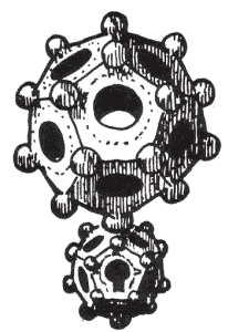
Their appearance struck us initially as ritual objects similar to the decorative reed spheres found in Southeast Asia; or as religious symbols such as the mysterious bronze and gold spheres found in France and Vietnam - which some say depict the ancient text of the Tao Teh Ching. It may well be that all of these hand-held objects served similar planning and mnemonic functions for the people who treasured and crafted them. (See illustration #2)
Viewing the stone polyhedra together, we can only conclude as Keith Critchlow does - that their intended use was for the study, comparison, and analysis of spherically determined systems of geometry. Given the apparent use of these stones as “planning models,” and given the apparent “extra wrap” of thongs on the tetrahedron - consider the result if the Neolithic craftsmen of these forms had decided to discover the ultimate in delineated spherical geometry models, a single sphere upon which would be combined all the wrappings and points of all five solids.
The most direct route to such a figure is as follows: Take the icosahedron wrapping pattern and combine it with the existing pattern of points and thongs on the dodecahedron. The combination of figures provides a form composed of 15 “great circles” which intersect at 62 predicted common points.5 (See illustration #3)
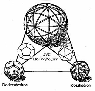
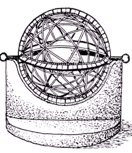
This figure, which synthesizes the dodecahedron and icosahedron with its 120 triangles, was not only known to the Greeks but to other civilizations much earlier. We believe that its geometry can be applied in two forms: the “girded sphere” or marked stone used for mapping, dowsing, or geometry (earth measure); and the armillary sphere or “celestial basket” used as an astronomical device to measure time via the solstices and daily sunrises. The armillary sphere casts a shadow on the captured stone within its framework (see illustration #4) - thus echoing the ancient analogy “As above, so below.”6
Returning to the creation of our ultimate spherical model, the second step would be to take the other figures - cube, tetrahedron, and octahedron - and lay out their line arrays over the existing 62 point pattern. You will find that not only is the 62 point system of vertexes compatible with the icosahedron and dodecahedron - but that all the leather thong patterns of all the polyhedral stones are precisely “mappable” over those same 62 vertexes. In fact, our surprised craftsman would soon discover that all five stone arrays can be overlapped one upon the other with different comer matchings until a beautiful polyhedron with 121 “great circles” and 4,862 points has been developed. This is the ultimate single sphere pattern which houses all five Platonic solids within multiple orientations (see illustration #5).

Plato’s description in the Timaeus of a cosmology based on the five regular volumes (tetrahedron, octahedron, cube, icosahedron, and dodecahedron) echoes Pythagorean teaching regarding the manifestation of the infinite within the finite. Plato postulates a metaphysics in which the four elements of Greek science - earth, air, fire, and water - are associated with four of the five solids. He mysteriously reserves his description of that most noble form used by the Creator to fabricate the universe as “a certain fifth composition.” Tradition relates the cube to earth, tetrahedron with fire, octahedron with air, icosahedron with water, and the dodecahedron with the universe or “prana/aether.” Because he had written that, “The earth viewed from above, resembles a ball sewn together from twelve pieces of skin,” we believe he related the dodecahedron to Gaia, the living planet earth. We also propose that Plato’s mysterious “fifth composition” is more complex than the dodecahedron - but based upon it.
We suggest that Plato’s most noble framework for building the universe is a form which unifies and supports all the forces operating simultaneously within the five regular solids, the four primary elements, and the earth (Gaia) itself - the Unified Vector Geometry 120 Sphere. We further contend that this sphere is the pattern upon which the ancients built their armillary spheres, which to this day are used to cast shadows for reading the solstices and equinoxes.
Contemporary researchers like Donald Cyr7 and Sir J. Norman Lockyer8, experts in archaeoastronomy, have again and again detected in the site layouts of ancient stone circles and cities, a circular plan of radiating lines diverging from sacred centers at angles of 22+, 11+, 46+, 90, 120 and 180 degrees. These radiating lines, it was found, consistently align with standing stones, stone circles, and sunrise/solstice marking points on mountain peaks and crest “notches” surrounding the site.
A related set of angles in the Megalithic landscape, 23 1/2 and 47 degrees, is equally regular but does appear to relate to celestial phenomena of the common variety. In many cases, these and the other angles link one sacred site to another miles distant. The basic triangle in our Unified Vector Geometry (UVG) 120 Sphere exhibits just these angles, at intervals strangely correspondent with those found by Lockyer, and Cyr and others.
Plato had travelled extensively while making notes for the Timaeus. His visit to Egypt would have brought him in touch with the historian/planners of the city of Cairo. Engineer/geometer Richard J. “Dick” Benson9 believes that Cairo is possibly the most ancient surviving example of a precise geometric site plan based not only on the angles discovered by Cyr and others but on angles which connect sites across continents and which - again - are almost eerily similar to those in the UVG 120 Sphere. (See illustrations #6, #7)

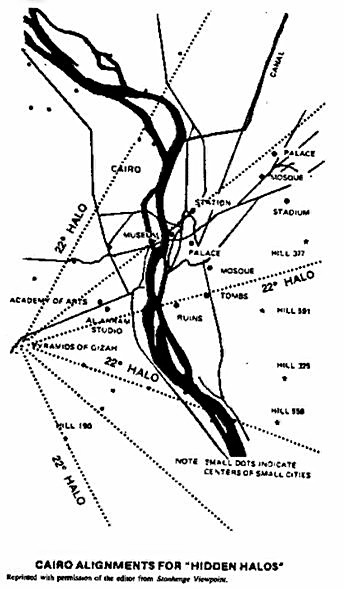
Could Plato have avoided in the Timaeus a direct reference to the simple dodecahedron as his framework for universal creation because he was still searching for “a certain fifth composition” which would satisfy the magnificent site plan of Cairo that Benson’s map implies? Or was he restricted by a secret vow to the Pythagorean Brotherhood not to reveal to the world the true form of Pythagoras’ compound polyhedron, which held all the solids within its form and had been used in the global grid and armillary sphere “planning models” for Cairo and other sacred cities?
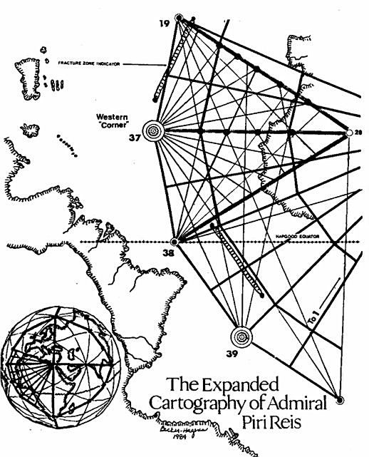
Since Plato, history has lightly sketched what seems to have been a sub rosa quest for a Cairo-centered mapping system, which would “square the circle” and/or show the way to the Holy Grail. (Interestingly, a 13th century writer named Wolfram described the Grail as a “precious stone fallen from heaven.”) Curious artifacts like the Piri Reis map, dated 1523 A.D., but believed to be a copy of an ancient Greek original, show “wind rose” lines converging on Cairo with angular divisions of 22+ and 11+ degrees (see illustration #8).
Could the Piri Reis map have been an extension of the site lines and solstice/sunrise markers which encircle ancient Cairo? Viewed “from above,” the major points on the Piri Reis map so nearly approximate points on our UVG 120 Sphere that we have included a sketch using our geometry and Piri Reis’ lines which attempts to complete the missing portion of the world map the Admiral originally drew.
The Piri Reis map and another unique document, the Buache map of 1737, contribute much toward our contention that early, possibly Pre-Egyptian civilizations possessed mathematical, astronomical, and geophysical skills equal to those in this confused “Iron Age.” Both maps possess highly accurate and unique views of the continent of Antarctica not known, supposedly, before the International Geophysical Year of 1958. (See illustration #9)
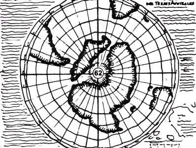
The Piri Reis map was found in Istanbul in 1929 and is said to have been copied from a map originating in the library in ancient Alexandria. The Buache map of 1737 is said also to be the result of copying ancient Greek maps. Both maps astonishingly depict Antarctica’s true land masses through their icy cover - though instruments to detect such land masses were not invented until 1958. Even if the maps are complete frauds, they still predict Antarctica’s true profile thirty years early.
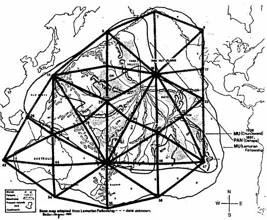
The matter of maps which can’t exist - but do - is a kind of continuing corollary avenue of research compatible with Unified Vector Geometry. The maps of the so-called mythical continents of Mu and Pan (as described in the channelled Oahspe, A New Bible in the Words of Jehovih; in the writings of controversial scientist/philosopher Sir James Churchward; and in revelations of the Lemurian Brotherhood to the Lemurian Fellowship in Ramona, California) were all made long before the geophysical year studies and the contemporary pioneering ocean cartography of Marie Tharp and Bruce Heezen (see illustration #10).
Returning to the maps of Piri Reis, Buache, and the ancient sea kings, what kind of planning models would an ancient mariner need to construct such maps? Ivan Sanderson, researcher into the unexplained, asked such questions in the 1960s and 70s - and with several associates, he set out to “pattern the mysteries” by taking full advantage of modern communication technology and statistical data analysis. His success was startling. His 1972 article in Saga magazine, “The Twelve Devil’s Graveyards Around the World,” plotted ship and plane disappearances worldwide, focusing attention on12 areas, equally spaced over the globe, in which magnetic anomalies and other energy aberrations were linked to a full spectrum of strange physical phenomena (see illustration #11).
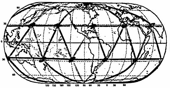
Highest on Sanderson’s statistical priority list was a lozenge-shaped area east of Miami, in the Bahamas, on the western tip of the infamous Bermuda Triangle. This area’s “high profile” of strange events, Sanderson concluded, was mostly due to the enormous flow of air/sea traffic in the area. Other zones of anomaly, though less familiar, were equally rich in disappearances and space-time shift occurrences. A pilot flying with passengers near the Hawaii zone suddenly found himself in a “dead zone” without instruments and unable to communicate beyond the cockpit. After flying some 350 miles, the “phenomenon” lifted and the pilot found that tower officials could find no measurable time had elapsed between the beginning of his “dead zone” experience and its end.
Another area of continuing disappearances and mysterious time-warps is the Devil’s Sea located east of Japan between Iwo Jima and Marcus Island. Here events have become so sinister that the Japanese government has officially designated the area a danger zone. Sanderson theorized that the tremendous hot and cold currents crossing his most active zones might create the electromagnetic gymnastics affecting instruments and vehicles. His theory is now being balanced against several.
These same areas, in the pattern of an icosahedron, have been mapped out in the Keys of Enoch (1977) by J. J. Hurtak but are explained as natural time-warp contact areas used by the Brotherhood. It is not unreasonable metaphysical theory to assume a pulse to the universe, an electromagnetic heartbeat which makes time appear to go backward and ahead - for planes of existence to manifest and disappear. What better spots for contact than Sanderson’s? (See illustration #12)
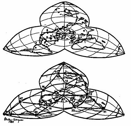
Ivan Sanderson and his energetic colleagues are surely the contemporary rediscoverers of what has come to be called the “Planetary Grid” - so named by Christopher Bird in an article which appeared in the New Age Journal of May 1975. Bird’s writing brought to light that a truly “morphogenetic”10 worldwide research effort, involving earth/human origins and grids, had taken off parallel to and as a result of Sanderson’s work. Bird wrote about three Russian researchers (Nikolai Goncharov, a Muscovite historian; Vyacheslav Morozov, a construction engineer; and Valery Makarov, an electronics specialist) who had published an article entitled “Is the Earth a Large Crystal?”
Their work, supportive of and following immediately upon Sanderson’s, had outlined a worldwide grid of points nearly identical to Sanderson’s12 and had added 50 more. These occured where Sanderson’s global icosahedron overlapped the Russians proposed combination of icosa and dodecahedron. These new lines and points, in conjunction with Sanderson’s, now matched most of the earth’s seismic fracture zones and ocean ridge lines as well as outlined worldwide atmospheric highs and lows, paths of migratory animals, gravitational anomalies, and even the sites of ancient cities.11
The tradition established by the Russians with the overlapping icosa/dodecahedron grid has been adopted by almost all grid researchers with the exception of New Zealand’s Captain Bruce Cathie who is working with the cubeoctahedron (Fuller’s vector equilibrium model, briefly discussed in the next section of this article). Among the rest, there are some common themes in the predictive science of the grid and some dramatic divergences. Those involved in what might be thought of as “classic geometries” use the model to predict physical events and measurable phenomena in the tradition of Ivan Sanderson: Athelstan Spilhaus (faults, seismic activity, continental drift); J.J. Hurtak (time warps, evidence of paraphysical grid line connections among pyramids in the Americas); A.M. Davie (coincident events). Another branch of theory centers in harmonics. Bruce Cathie is meticulously charting the courses of phenomena grouped under the title of “UFO.”
Michael Heleus has undertaken a universal theory of harmonics that he calls “Astrosonics” and is attempting to develop a practical health technology for people to get “in tune” with Gaia by reactivating the harmonics of the cosmic time and place of their birth. He believes that planetary grid harmonics can and will be manipulated if we do not develop a responsible stewardship for this profound and powerful resource. John Sinkiewicz has developed a theory not unlike that of Donald Cyr - that we may be making an enormous mistake if we assume that “Nature” is natural, that it’s always been like this - with wild climate swings, tornadoes, pole wobble, and the like. Sinkiewicz believes the earth energy grid is out of alignment, is no longer anchored at the North and South Poles, and that New Age spiritual communities around the world are gradually rediscovering the new grid and building their sacred sites in accordance to activate it.
Ray Stoner, working with shamans among the Central American and North American Indians, has gone a step further and is searching the museums and ruins for potential pieces of the grid “power system” he believes was once in operation around the world and centered in the pyramids. His is potentially the most politically revolutionary theory since so many key “artifacts” (such as the unusual stone yoke shown in illustration #13) are found in the museums and collections of the very wealthy.

The work of both Stoner and Sinkiewicz provide something of a bridge to the work of the dowsers, notably Christopher Bird (who dowses for information); Terry Ross (former President of the American Society of Dowsers who practices a kind of dowsing of manifestation for needy Third World countries); and the thousands of dowsers here and in Europe who are slowly uncovering a transcontinental network of lines based on a kind of sixth sense of the flow of Gaia and the “ley” of the land.
This same type of work has been carried on in China and Japan for thousands of years as Geomancy - the identification of archetypes of the tiger and the dragon in the landscape, and the siting of buildings and their functions with respect to balancing these forces with the flow of underground water and cosmic energy. A branch of dowsers in this country (including Tom Bearden, Ken MacNeill, Toby Grotz, and Walter Baumgartner) are pushing the politics of grid research into the development of practical “free energy devices” that will be decentralized, affordable, and supportive of personal freedom.

A New Synthesis: Predictions and Speculations
In 1983, upon first seeing a drawing of the Russian planetary grid in Moira Timms’ book Prophecies and Predictions, we immediately recognized the work of R. Buckminster Fuller - who had spent a lifetime developing his models and theory of “nature’s comprehensive building system.” There before us, adapted from Chris Bird’s article, was a drawing of an “incomplete” geodesic sphere - in fact, the exact sphere upon which Fuller had based his geodesic domes and much of his theory of synergetic geometry.
With the simple addition of 60 lines which connected the vertexes of Sanderson’s icosahedron to the vertexes of the added Russian dodecahedron we had duplicated the Neolithic craftsman’s model and established Fuller’s 15 “great circle” polyhedron as a key link in the chain of grid ideas.
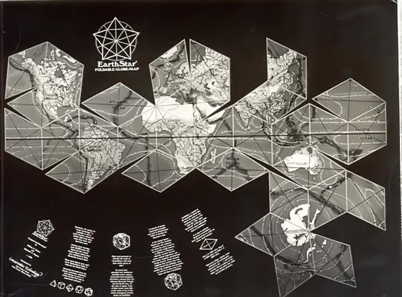

After locating Bird’s original article and finding the Russian work in Chemistry and Life, a USSR science magazine, we went into what many researchers, writers and artists call “curiosity/compulsion syndrome.” Everything we seemed to hear, see, read, and even eat related “in some way” to the planetary grid. Three months after glancing at that Russian drawing, our library had totally changed, cardboard and store-bought globes littered our tables, and we were driving to Washington, DC. to meet with Chris Bird.
Since that time nearly a year ago, a cascade of information from friends, students, co-researchers, and others has brought us to this current presentation.11
We propose that the planetary grid map outlined by the Russian team Goncharov, Morozov and Makarov is essentially correct, with its overall organization anchored to the North and South axial Poles and the Great Pyramid at Gizeh. The Russian map, however, lacks completeness, in our opinion, which can be accomplished by the overlaying of a complex, icosahedrally-derived, spherical polyhedron developed by R. Buckminster Fuller. In his book Synergetics2, he called it the “Composite of Primary and Secondary Icosahedron Great Circle Sets.”
We have shortened that to Unified Vector Geometry (UVG) 120 Sphere, because of the form’s elegant organization of 121 “great circles” running through its 4,862 points. We use the number 120 due to its easy comprehension as a spherical polyhedron with 120 identical triangles - all approximately 30°, 60° and 90° in composition. All other forms within our Unified Vector Geometry use shape names and numbers which refer to the quantity of smallest UVG Basic Triangles within a given form - and the number of named forms in the UVG 120 Polyhedron or Sphere. Thus, when we refer to our “Pac-Man” pentagons which appeared in our first planetary grid map, you should know that we also call them UVG 10/12 Pentagons, because ten of our Basic Triangles create each pentagon and there are twelve pentagons in the UVG 120 Sphere and Polyhedron.
In our commercially available EarthStar foldable globe/map,12 we use the UVG 4/30 Diamond (or rhomb). Within this diamond are 4 Basic Triangles, and there are 30 diamonds in the 120 Polyhedron and Sphere (see illustrations #15, #16). This figure permits not only easier assembly of the UVG 120 Polyhedron (in the form of the rhombic triacontahedron) than our pentagon-based hexakis icosahedron (see illustration #14), but also permits easy orientation to the four compass points when working with the globe or map (see illustration #17, and chart).

And now we come to our most fascinating discovery of all - the predictive utilization of the Basic Triangle. It is this figure which we knew to be the result of multiple mappings of all five regular Platonic solids on the surface of a sphere or combined polyhedral form (icosahedron and dodecahedron) like the hexakis icosahedron and/or rhombic triacontahedron. What we hadn’t known until recently was that R. Buckminster Fuller had not only drawn and analyzed the Basic Triangle, but had also noted all its internal angles in planar and spherical notation (See illustration #18).
Also what we hadn’t known until quite recently was that this triangle could predict so many kinds of events and geographic patterns, at so many times and places throughout human history. As mnemonic tools, the UVG Basic Triangle and 120 Sphere store and integrate biology, metaphysics, mythology, astronomy, geology, human struggle - or in the words of Pythagoras, “the supernatural within the finite.”

BASIC TRIANGLE - Unified Vector Geometry (UVG)
Illustration #18 Within the Basic Triangle’s 30, 60 and 90 degree angles (whose lines and vertexes define 120 of those triangles, 62 major grid points, and 15 major great circles) are arrayed 45 intersection points and 16 lines which manifest 106 minor great circles and 4800 minor points over the face of the globe (UVG total is 4862 points). By noting the three numbers for the Basic UVG Triangle followed by a single number for a minor grid point (example - Oxford, England falls near 2-11-20/2 on our European map, Illustration 22); two numbers for a minor grid line (example - Italy’s boot heel is defined by Basic Triangle 2-1-20/43-28 minor line).
* * * * * * * *
On September 1, 1983, in the pre-dawn sky, a 747 jumbo jet is cruising over the last island in the Aleutian chain. The Korean pilot is relaxed and having coffee as his autopilot is switched onto “Red Route 20,” the standard course set for all airliners out of Anchorage to avoid coming within 25 miles of Russian territories north of Japan. At 3:18 a.m., Japan time, the pilot radios that his position is 115 miles south of Hokkaido Island in northern Japan.
Ground radar, however, locates the plane 115 miles north of Hokkaido and well into Soviet airspace. At 3:27 a.m., a garbled distress call goes out from the plane - the last message to be sent from KAL 007. Glance at our illustration of the path of the plane on the UVG 120 Sphere and imagine this scenario. KAL 007 crosses planetary grid point 6, approximately 1800 miles east/southeast of Anchorage, Alaska about 1:00 a.m. Thursday, September 1, 1983. The positions of the sun and moon begin bringing enormous energy into the vector line which stretches from the tip of the Aleutian chain to the Mongolian/Soviet mainland west of Sakhalin Island. (See illustration #19).
Silently, without alerting Captain Chun the pilot, the geo-compass in the autopilot’s guidance system is slowly pulled 22.24° off its corrected north bearing, altering the course of the plane by that amount while simultaneously beginning to energize and speed up the magnetic odometer in the plane’s computer navigational system. A fractional addition of a mile is added to each actual mile travelled at an accelerating rate. As the crew and passengers talk about the festivities ahead in Seoul, other smaller aircraft appear behind the 757 airliner. No communication takes place because the pilots of the smaller aircraft are never given international radio frequencies for fear they will defect.
Then an explosion, and another, thunder into the ears of the crew. Captain Chun begins his radio distress call, but in four short minutes the lives of all 269 aboard are gone. Compare the above to the flight of KAL 902 out of Paris, bound for Anchorage. The date is April 20, 1978. In the predawn sky over grid point 11, in northern Scotland, the 707’s guidance system compass begins to read to an energized line running up from the Bermuda Triangle. Captain Kim Chang Kyu, a veteran KAL pilot, doesn’t notice the bearing of his plane changing slowly to 82.25° off his near polar great circle route. The plane moves onto an infill grid line over Greenland.
By the time the plane moves into the next basic grid triangle, a passenger notices that the Arctic sun which had been on his right is now on his left. Before he can alert Captain Kyu, a Russian missile slams into the fuselage, killing two passengers and forcing the plane to land on a frozen lake south of Murmansk. As Russion troop vehicles appear on the shore, Captain Kyu apologizes to his passengers saying that he had felt something had gone wrong with his compass before the Russian planes had appeared.
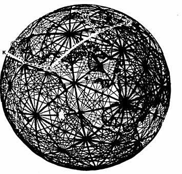
Both incidents, KAL 007 and KAL 902, were based on predawn crossings of major grid points (6 and 11) by sophisticated aircraft which then, unbeknownst to their crews drifted off their programmed course and followed minor grid lines until shot down by uncommunicative Russian pilots.
We predict that there will be other incidents such as these occuring in the future, and not just off the Russian coastline. We feel that incidents such as these help pinpoint the evidence about which Ivan Sanderson theorized in 1972 - that there is a predictable physical pattern of energy events working through the system Chris Bird called the planetary grid.
The “predictable physical pattern” was discovered in quite a different context from earth energy research. While discussing the physical structures which support his theories of geometry (in Synergetics 1), R. Buckminster Fuller presented evidence that the micro-photography of balloon skin layers has, under near ideal conditions, produced visible patterns identical to our UVG 120 Sphere surface structure. As interior gas molecules ricochet off the inner surface of the balloon, they manifest their kinetic energy in “great circle” patterns of “shortest distance” frequency. If the ambient temperature of the balloon’s exterior can be delicately balanced and equalized - the pattern of the UVG 120 sphere can become visible.
Given that the earth’s original formation was based upon the clustered gravitational packing of quadrillions of vibrating cosmic dust particles and gases, in the early eons of our solar system - we feel the analogy of the balloon skin is strongly comparable to the lines of vectorial energy we hypothesize are transitting the earth’s surface. Our Basic UVG Triangle reveals a 120th section of these energy lines - and we think that it is totally predictable to find detailed physical manifestations of these lines, particularly on continental land masses.

A possible piece of supporting evidence comes from the Vail/Cyr canopy theory - which proposes a more equalized world climate during the Megalithic period (see footnote 7). If the global climatic ambience were more regularized than it is today, it is possible that grid energy manifestations were also more visible and potentially more available for applied use. Extending the speculation back further in time, the deluge myth found in the myths of virtually all cultures can perhaps be traced to some (Atlantean?) technological endeavor that caused a partial and devastating collapse of the canopy. Before this collapse, the poles may well have been free of ice (hence the existence of maps such as Piri Reis and Buache).
Polar ice caps may have formed relatively rapidly in the period of climatic disequilibrium. In this light, Cyr’s Megalithic canopy theory is correspondent with our own findings in analyzing Megalithic sites. We have documented in the illustrations of Ireland, Britain, and Europe which follow; a patterned interface of man-made constructions, dating to the Megalithic period, which correspond to our proposed “infrastructure” for the icosa/dodecahedral planetary grid. New evidence that we are just beginning to analyze13, and which includes patterns of mounds within the central United States and the curious “lines” of the Nazca area of Peru, exhibits the same close correspondence. This proves to us that past cultures have been aware of, and attuned to, the energies of the UVG 120 Sphere.
A second analogy to earth’s processes we feel comfortable with is the Russian crystal earth concept, whereby coalesced volcanic matter which formed the earth settled initially into a crystal form (UVG 120 Polyhedron). The Russians theorize that with rotation and centrifugal redistribution of molten surface material, the earth soon took on its spherical form but retains the deep crystal structure and its predictable manifestations. One of these is based on the principle that crystal edges and vertexes carry most of the thermal, structural, and electromagnetic energy events developing from within and imposed upon the surface material.
Satellite cameras and infrared/radar instruments have already documented thermal/structural energy developments along the globe’s UVG 120 Polyhedral edges. It remains for traditional science to develop instruments as sensitive as an experienced dowser’s “earth sense” before the full spectrum of the earth’s electromagnetism can be tuned like a “crystal set” radio to a wide range of frequency band widths. (See illustration #20)
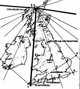
It is clear to us that Megalithic peoples knew all that we now know about the planetary grid and then some. The stones which they so carefully placed upon ley lines were used to communicate with anyone else linked via common telluric energy flows. (See illustration #21) These energy flows are being mapped today both by dowsing groups interested in this rarest form of “harmony of the spheres” and ley line hunters (such as John Michell and others in the great tradition of Alfred Hawkins) who wonder at the coincident siting of modern towns and significant structures upon ancient stone remains from the past. (See illustration #22)

We also hold that a major reason why Megalithic groups were so interested in astronomy and the precise calculation of solar and lunar phases was that within these calculations rested the predicted “pulses” of energy through the grid at different times of the year. Captain Bruce Cathie, an airline pilot and prolific grid researcher from New Zealand, has theorized for years regarding the grid’s pulsing harmonic pattern and how it might relate to UFO and “sky light” phenomena. UVG is applicable to this research in a curious way. R. Buckminster Fuller was constantly experimenting with spherical packing - how many equal sized spheres can you fit into a given polyhedron, and how can the arrangement be shifted (keeping the same number of spheres) into a different one. As it happens, the UVG 120 Polyhedron shifts back and forth with the cubeoctahedron (or vector equilibrium model, as Fuller calls it) that Cathie uses and that seems to map UFO phenomena. We can hypothesize the heartbeat of Gaia.

The ancients evidently patterned their universal and local holidays and feasts to conjoin with the interlocking events between the grid and solar system energy fields. Both KAL 007 and KAL 902 tragedies occurred during significant holiday periods - 007 during a major Hindu feast for Vishnu, and 902 during Good Friday/Passover. We have also come to speculate that the stone polyhedra introduced early in this article may have been used as charts and terrestrial guides for large pilgrimages which took place over major regions of the globe. (See illustration #23)

Spiritually and intellectually hungry travellers may well have visited major energy collection points on the grid, each having its own flavor and delight. The hand-held model, or map, attuned as it was to the solar system and to the monuments and towns one would pass along the way, was a complete tool for the voyager. (See illustration #24) It may even have charted the cycle of transcontinental festivals in much the same way that the Australian aborigines are able to coordinate huge religious gatherings with (seemingly) no deliberate planning. The “bureaucracy” is maintained only in the flow of time through lines of kinship, lines of sight, and sacred lines of the tchuringa.
Footnotes
1. Let us pray that another plague (AIDS, cancer, heart disease...) will not be necessary in completing this scenario.
2. Taken from “Gathered Notes Among Friends on: The Crystal’s Dance.” a publication from Chrystal Hill Farm, 9411 Sandrock Rd., Eden, NY 14057.
3. Jeffrey Goodman is a highly controversial, free-thinking independent archaeologist and author (We Are the Earthquake Generation; The Genesis Mystery) who was among the earliest pioneers of “psychic archaeology.” His current work focuses on health and crystals.
4. We want to thank Robert Cowley of the Research into Lost Knowledge Organization (RILKO, 8 The Drive, London N11 2DY England) for introducing our work to A.M. Davie of Alloa, Scotland. In our long, enjoyable correspondence with Mr. Davie, we have found him to be a gifted scholar of ancient languages and cultures, a keen observer of coincidence, and (as evidenced by reports of his work with SRI in California) inventor of a predictive system for events as seemingly unrelated as earthquakes, spontaneous combustion, cardiac infarction, mechanical failure, and crime.
5. We call this figure the Unified Vector Geometry (UVG) 120 Polyhedron, and hope that the new planetary grid terminology we introduce will be both clear as well as reflective of the ancient and modern contributors to its development. In one of his first letters, A.M. Davie wrote: “I came on one word yesterday which has been adopted by modern mathematics, and causes me considerable problems. Where two lines intersect, the word to describe this intersection is now termed “Vector.” “An Bheachd-Or” is the ancient name for ‘The Golden Circle.” and is a geometric figure of definite lineal measurements associated with the movements of the Solar System. The word ‘Bheachd,” pronounced as “Vect,” is according to my dictionary: Notice, Attention, Observation, Perception, Feeling, Ambition, Ideas, Conception, Distinct Recollection/Memory, Opinion, Behavior, Sense/Wisdom, Judgment, Conceit, Aim, Intention, Carriage, Vision, Eyesight, Surity, Covenant, Multitude, CIRCLE and RING.”
6. Curiously, “armilla.” the root in armillary sphere, has the meaning of “iron ring” and “golden coronation bracelet.”
7. Donald Cyr. editor of Stonehenge Viewpoint, and his friend Lawrence W. Smith have championed and greatly expanded the ideas of Isaac N. Vail since their high school days in the 1930s. As an archaeoastronomer, Cyr’s notion is that much can be gained in understanding past civilizations if we do not make the uniformitarian assumption that things (such as climate) have always been roughly as they are now. The Vail/Cyr “Canopy Theory” supposes that during the Megalithic period, a layer of ice crystals formed over the earth at a height of about fifty miles. This could have produced something like the greenhouse effect - a mild, relatively windless climate with the atmosphere at the dew point - over much of the earth, with spectacular halos around the sun and moon. The light of the sun shining through the ice crystals would have been so brilliant that it would have been impossible to gaze at it directly. Because of the optics of tight refraction through the ice crystals, however, each halo edge would fall 22 degrees from the center of the sun - with a less common, but equally regular secondary halo occuring 46+ degrees from the center. This glorious sky phenomenon could have given man the world over a predictable common unit of measure. A related effect of the canopy may also help explain the seemingly phenomenal knowledge of astronomy among the ancients. Joe Jochmans (writing as Jalandris) received an honorary doctorate for his interpretation of Genesis based upon canopy and other earth energy effects. He claims that the canopy may have magnified the light from the stars and planets and made them appear closer and much easier to view with the unaided eye than is possible today. His other fascinating theory is that the Megalithic canopy was preceded by an even larger more magnificent canopy that ultimately collapsed - producing the great deluge and rain of forty days and forty nights that is recorded in the sacred tradition of virtually every culture on earth.
8. Sir J. Norman Lockyer, writing in the early part of this century, was perhaps the first contemporary archaeoastronomer - having discovered significant alignments between megaliths and celestial bodies. His work was largely rejected, as were his very humanitarian politics that echo his British predecessor Alfred Russel Wallace, though it forms the base for later work reinitiated by Alexander Thom.
9. Dick Benson’s work, formally presented in June of this year to the U.S. Psychotronics Association meeting in Atlanta, holds the promise of a unified field of letters and numbers. His “World’s Oldest Jesus F Map” is reprinted to give not only a glimpse of the complex geometry employed by the ancient planners at Cairo but to hint at the sophistication and refinement of Benson’s work. One of his most exciting archaeological discoveries is a virtually identical “site plan” based on the pyramids at Teotihuacan in Mexico.
10. “Morphogenetic fields” were introduced by British biologist Rupert Sheldrake in another controversial book, A New Science of Life: The Hypothesis of Formative Causation, suggested for burning by Nature magazine in Britain. The theory is complex, implying that once something comes into existence (an idea, a gene code, a chemical structure...) it exclusively fills a specific cosmic niche; sends a kind of formative energy throughout Gaia; and makes its appearance quickly and with increasing ease throughout the world. Currently the Tarrytown Group in New York is offering a prize of $10,000 for the best experimental design to test Sheldrake’s theory.
11. Over the past year and a half, students in anthopology and environmental planning at Governors State University have undertaken the tedious, not-yet-computer-assisted task of checking the fantastic claims of the Russian visionaries. (Several students, among them Penny Fnck, Tim Donovan, Jay Rick, Denis Chapman, John Lerch, and Mary BoyaJean have put in far beyond the required time and effort and have been brave enough to criticize and question almost everything!) In general, the students’ work has involved the translation of data from various atlases and sourcebooks from their Mercator, conical and spherical projections to the hexakis icosahedron and rhombic triacontahedron that we use for standardizing data. For the most part, the Russian claims hold up but are substantially over-generalized - particularly with respect to electromagnetic aberration.
12. EarthStar is printed in full color on heavy cardstock. 17 1/2” x 22 1/2”, and is suitable for framing - but has been pre-punched and scored for folding into an 8”-diameter rhombic triacontahedron globe with stand. A plastic UVG 4/30 Diamond overlay infilled with UVG 120 Sphere lines is included. The EarthStar is available exclusively at VortexMaps.com.
13. There are many people whose contributions, insights, and encouragement have been essential in keeping us so absorbed in this research - especially Tim Wilhelm, Robert Warth, Robert Gulick, Edwin Wright, John Michell, R. Gary Smith, Robert Lawlor, Jose A. Arguelles, the Rev. Dorothy Leon and L. Taylor Hansen.
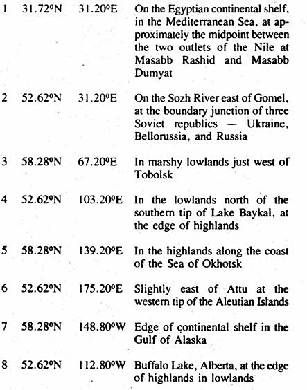
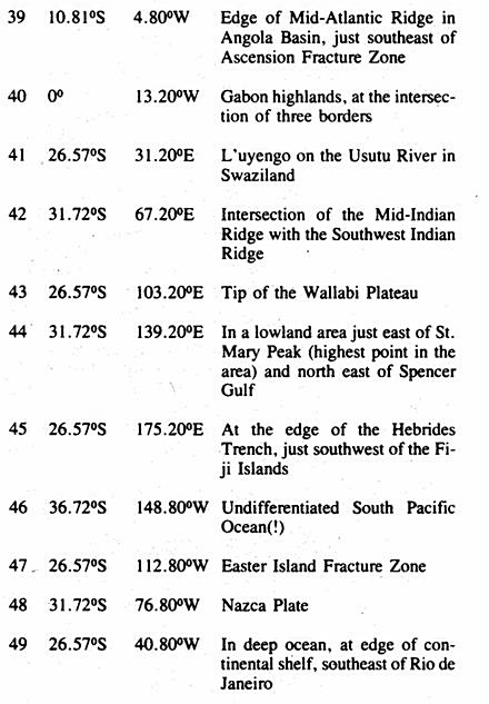
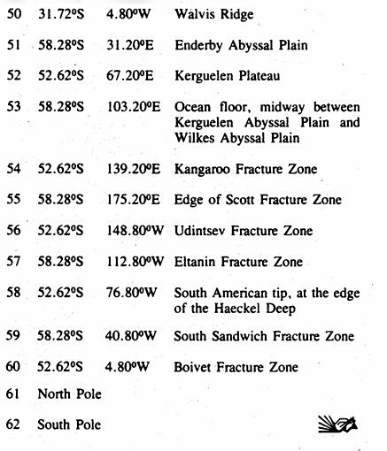
CHART: Becker-Hagens Planetary Grid System Coordinates


Appendix - Planetary Grid, by Chris Bird (1975)